Oct 2015- LiDAR’s name sounds a lot like Radar, because it is similar. LiDAR is “Light Detection And Ranging.” Like radar, it’s a technology used to see what the human eye can’t see, either close up or far away.

LiDAR uses pulsed lasers instead of the radio waves that Radar uses. As a data collection system, LiDAR collects 3D data from an area of interest. It is often used for construction site mapping, measuring geological forms, vegetation mapping, surface and texture mapping, and just about anything else that has slopes, contours, bumps, branches, corners, or other surfaces.Contrary to popular belief, LiDAR cannot see through clouds, fog, smoke, or rain. It is possible to sometimes see through foliage for forestry projects, and can see through tree cover general rule of thumb is that if light can penetrate it then LiDAR can as well. As depicted below you can see vegetation and trees, and even remove them via software to produce a bare earth model. This is critical when Digital Terrain Models are required by a VDC or engineer for earthworks, measurement, etc.
There are many use cases for LiDAR, and Yuneec is deeply focused on several of those cases. For example, powerline inspections are challenging, costly, and time consuming. LiDAR not only dramatically speeds the process, but reduces cost and increases safety. Power lines typically require scans of 30-40 Points per Meter (ppm) and even inexpensive LiDAR systems such as the one pictured here, is easily able to scan at this low rate.
The primary benefit of UAS and LiDAR, is that LiDAR was once relegated only to manned aircraft that need to fly reasonably high. The higher the LiDAR unit is from the area of interest, the lower the resolution will be. Ideally, most surveys are accomplished at 150’ (50 meters) in altitude (or less) for the best resolution. UAS (without a waiver or COA) may not fly above 400’, while fixed wing manned aircraft may not fly below 500’.


A Quanergy M8 LiDAR system (being tested for release) mounted on the Yuneec H920+ UAS system.
The LiDAR workflow is relatively straight-forward.
- Identify the area to be surveyed.
- Determine the desired resolution.
- Create a mission plan to match the area and desired resolution.
- Fly the mission.
- Transfer the LAS files to a computer for post-processing in an application of preference.
- Data may be used for creating/viewing a point cloud, analysis, or creating the benchmark for repetitive flight to display changes in any sort of environment.
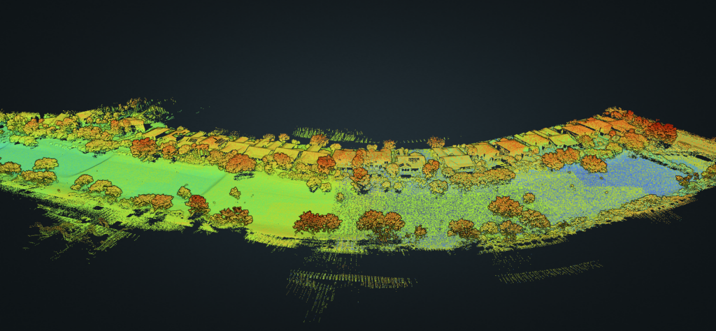
In the image below, the 3D LiDAR scan provides historical information that may be used as a baseline for future scans

LiDAR can demonstrate live video. In a security scenario, a UAS hovering over an area at an altitude of 200’ can identify movement and even facial features. This makes LiDAR an outstanding candidate for portable area surveillance and motion detection.
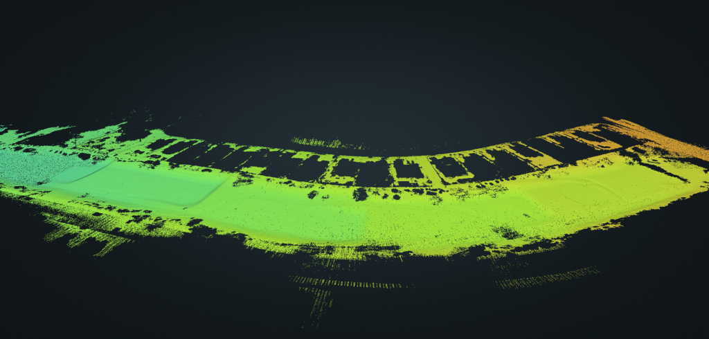
LiDAR is also frequently used to plan corridors for utility lines as shown in the image below;


Leave a Reply